The Wilderness We Bought from France
- Publication: The Cosmopolitan
- Date: May 1898
- Author(s): Charles F. Manderson
- Publisher: International Magazine Co.
- Publication Place: New York, NY
- Volume: 25
- Pages: 69-79
- TEI XML: transmiss.per.manderson.1898.xml
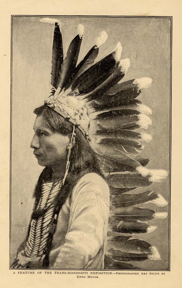
A Feature of the Trans-Mississippi Expostion.—Photographic Art study by Enno Meyer.
THE WILDERNESS WE BOUGHT FROM FRANCE.
BY CHARLES F. MANDERSON.
THE man who administered the oath of office to the first President of the United States was destined a few years later to render a still more illustrious service to his country.
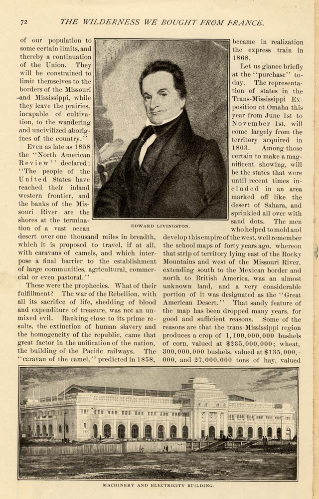
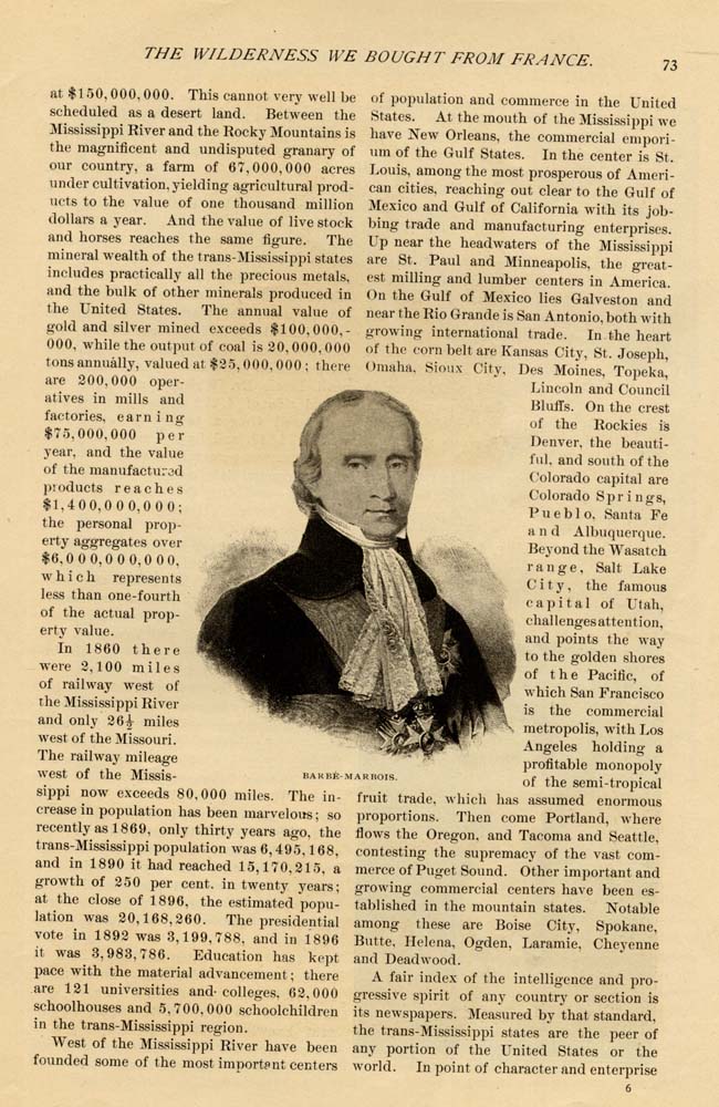
The charm still lingers on this old page of our history, weighted as it was with such immeasurable consequences, not realized by our forefathers. Every schoolboy knows the story of Mr. Livingston's appointment as American minister to France; of his instructions from President .Jefferson to purchase the Island of Orleans for a dockyard and depository; and of the minister's amazement when Marbois, the French treasury minister, offered to sell him, not an island, but a domain of imperial extent, the heart of the continent, reaching from the Gulf of Mexico to the English possessions on the north.
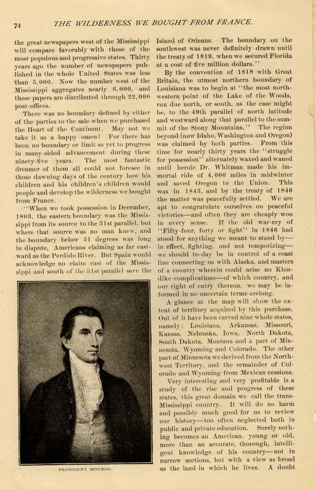
The President had been authorized to expend two millions of dollars, but this proposal called for fifteen millions. Mr. Monroe was sent over as an associate of the minister, but Mr. Livingston had assumed the responsibility before Mr. Monroe's arrival, and had practically accepted the proposed terms, as there was no time for delay. Both ministers, on April 30, 1803, con cluded a treaty whereby France ceded to the United States the vast territory known as Louisiana, "forever and in full sovereighty."
Then the storm broke. The purchase, undeniably, was somewhat revolutionary, and thoroughly unconstitutional, as affecting future membership in the Union, and as menacing the rights of the original parties to the "Federal Contract." Mr. Jefferson, himself a strict constructionist, did not consider it a constitutional act; "the executive," he said, "has has done an act beyond the Constitution. The Legislature must ratify it and throw themselves Upon the country for an act of indemnity." The Senate ratified the treaty and conventions, and on December 20, 1803, the territory of Louisiana passed to the United States. Our most interesting notes. aside from the question of the legality of this acquisition, relate the arguments brought forward by the opponents to the purchase. "Some were worried lest the East should become depopulated, lest a great emigration should set in, lest old men and young men, abandoning homes and occupations, should cross the Mississippi and perhaps found there a republic of their own. Some feared that mere extent of territory would rend the republic apart; that no common ties of interest could ever bind together under one government men who fought Indians and trapped bears around the headwaters of the Missouri and men who built ships and caught fish in the harbors of the Atlantic Ocean." And then the purchase would enormously increase the public debt. Two millions for an island and possibly as much ground on the main-
But few of the men of 1803 really under-stood the vast importance of the Louisiana purchase, in its relation to the development of American nationality. That which now makes the crowning pride of the American citizen, that the states of the Union are spread from the Atlantic to the Pacific, was held then by many patriots as the extreme of danger. Though the Lewis and Clark expedition of 1804 and succeeding years gave the first accurate information regarding the basins of the Missouri and the Columbia, thus throwing a flood of light upon the then unknown part of our newly acquired territory, still the opposers of expansion remained unconvinced. As late as 1825 this feeling was still strong. Beside the immense area on this side of the Stony (Rocky) Mountains, con-tamed in this purchase, there were also the lands lying beyond, which now constitute the states of Idaho, Oregon and Washington; and in 1824-5 a strong effort was made in Congress to secure this territory against the conflicting claims of Great Britain. Mr. Smyth, of Virginia. declared in the House that "the limits of the federation could not be safely extended beyond the Stony Mountains: he would not object to one or two tiers of states beyond the Mississippi. but no further." In the Senate, Mr. Dickerson, of New Jersey, pronounced the bill absurd. "A member of Congress, " he said, "traveling from his home to Washington and return, would cover a distance of 9, 201) miles; at the rate of thirty miles per day, and al-lowing him forty-four days for Sundays, three hundred and fifty days would be consumed, and the member would ha e fourteen days in Washington before he started home: it would be quicker to come around Cape Horn, or by Behring Straits, Baffin Bay and Davis Strait to the Atlantic. and so to Washington. True, the passage is not yet discovered, except upon our maps. but it will be as soon as Oregon is made a state." Mr. Dickerson's geographical eloquence was so effective that the bill, on his motion, was tabled.
So much stress upon the old story, be-cause this is the stone almost rejected by the builders.
Prophecies of evil grew with the years. Morse in his "Universal Geography" declared: "All settlers who go beyond the Mississippi River will be forever lost to the United States." Pike, whose name is attached to the giant peak that was to serve as a magnet to draw adventurous spirits from the East across the plain, condemned by him to ever-lasting sterility, made official report to the war department: "From these immense prairies may be derived one great advantage to the United States, namely, the restriction
 of our population to some certain limits,and thereby a continuation of the Union. They will be constrained to limit themselves to the borders of the Missouri and Mississippi, while they leave the prairies incapable of cultivation, to the wandering and uncivilized aborigines of the country." Even as late as 1858 the "North American Review" declared: "The people of the United States have reached their inland western frontier, and the banks of the Missouri River are the shores at the termination of a vast ocean desert over one thousand miles in breadth, which it is proposed to travel, if at all, with caravans of camels, and which inter-pose a final barrier to the establishment of large communities, agricultural, commercial or even pastoral."
Edward Livingston.
These were the prophecies. What of their fulfillment? The war of the Rebellion, with all its sacrifice of life, shedding of blood and expenditure of treasure, was not an unmixed evil. Ranking close to its prime results, the extinction of human slavery and the homogeneity of the republic, came that great factor in the unification of the nation, the building of the Pacific railways. The "caravan of the camel," predicted in 1858, became in realization the express train in 1868.
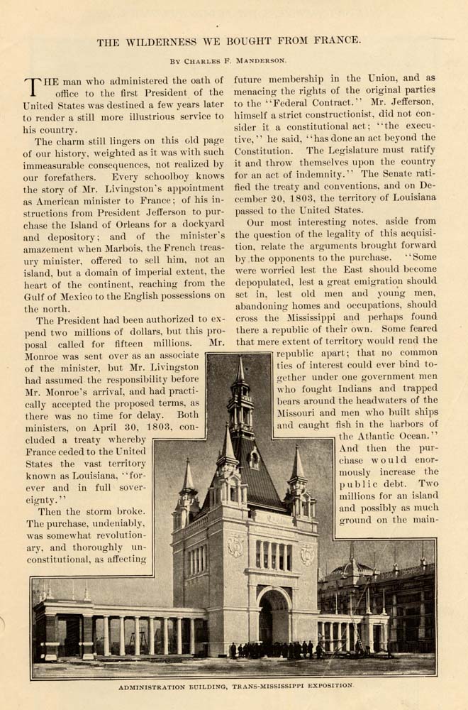
Let us glance briefly at the "purchase" today. The representation of states in the Transm-Mississippi Exposition at Omaha this year from June 1st to November 1st, will come largely from the eterritory acquired in 1803. Among those certain to make a magnificent showing, will be the states that were until recent times included in an area marked off like the desert of Sahara, and sprinkled all over with sand dots. The men who helped to mold and develop this empire of the west, well remember the school maps of forty years ago. whereon that strip of territory lying east of the Rocky Mountains and west of the Missouri River, extending south to the Mexican border and north to British America, was an almost unknown land, and a very considerable portion of it was designated as the "Great American Desert." That sandy feature of the map has been dropped many years. for good and sufficient reasons. Some of the reasons are that the trans-Mississippi region produces a crop of 1, 100, 000, 000 bushels of corn, valued at $235,000,000: wheat, 300, 000, 000 bushels, valued at $135, 000,000, and 27,000,000 tons of hay, valued
 at $150,000.000. This cannot very well be scheduled as a desert land. Between the Mississippi River and the Rocky Mountains is the magnificent and undisputed granary of our country, a farm of 67, 000, 000 acres under cultivation, yielding agricultural products to the value of one thousand million dollars a year. And the value of live stock and horses reaches the same figure. The mineral wealth of the trans-Mississippi states includes practically all the precious metals, and the bulk of other minerals produced in the United States. The annual value of gold and silver mined exceeds $100,000.-000, while the output of coal is 20, 000, 000 tons annually, valued at $25, 000, 001) : there are 200.000 operatives in mills and factories, earning $75,000,000 per year. and the value of the manufacture products reaches $1,400,000,000; the personal property aggregates over $6,000,000,000. which represents less than one-fourth of the actual property value.
In 1860 there were 2,100 miles of railway west of the Mississippi River and only 26, miles west of the Missouri. The railway mileage west of the Mississippi now exceeds 80,000 miles. The in-crease in population has been marvelous; so recently as 1869. only thirty years ago, the trans-Mississippi population was 6,495,168, and in 1890 it had reached 15,1 7 0.215, a growth of 250 per cent. in twenty years; at the close of 1896, the estimated population was 20,168, 260. The presidential vote in 1892 was 3,199.788. and in 1896 it was 3, 983, 786. Education has kept pace with the material advancement; there are 121 universities and colleges, 62,000 schoolhouses and 5,700.000 schoolchildren in the trans-Mississippi region.
West of the Mississippi River have been founded some of the most important centersof population and commerce in the United States. At the mouth of the Mississippi we have New Orleans, the commercial emporicun of the Gulf States. In the center is St. Louis, among the most prosperous of American cities, reaching out clear to the Gulf of Mexico and Gulf of California with its jobbing trade and manufacturing enterprises. Up near the headwaters of the Mississippi are St. Paul and Minneapolis, the greatest milling and lumber centers in America. On the Gulf of Mexico lies Galveston and near the Rio Grande is San Antonio, both with growing international trade. In the heart of the corn belt are Kansas City, St. Joseph, Omaha, Sioux City, Des Moines, Topeka, Lincoln and Council Bluffs. On the crest of the Rockies is Denver. the beautiful, and south of the Colorado capital are Colorado Springs, Pueblo. Santa Fe and Albuquerque. Beyond the Wasatch range, Salt Lake City, the famous capital of Utah, challenges attention, and points the way to the golden shores of the Pacific, of which San Francisco is the commercial metropolis, with Los Angeles holding a profitable monopoly of the semi-tropical fruit trade, which has assumed enormous proportions. Then come Portland, where flows the Oregon. and Tacoma and Seattle, contesting the supremacy of the vast commerce of Puget Sound. Other important and growing commercial centers have been established in the mountain states. Notable among these are Boise City, Spokane, Butte. Helena, Ogden, Laramie. Cheyenne and Deadwood.
A fair index of the intelligence and progressive spirit of any country or section is its newspapers. Measured by that standard, the trans-Mississippi states are the peer of any portion of the United States or the world. In point of character and enterprise
 the great newspapers west of the Mississippi will compare favorably with those of the most populous and progressive states. Thirty years ago the number of newspapers published in the whole United States was less than 5.000. Now the number west of the Mississippi aggregates nearly 6,000, and these papers are distributed through 22, 000 post-offices.
There was no boundary defined by either of the parties to the sale when we purchased the Heart of the Continent. May not we take it as a happy omen? For there has been no boundary or limit as yet to progress in many-sided advancement during these ninety-five years. The most fantastic dreamer of them all could not foresee in those dawning days of the century how his children and his children's children would people and develop the wilderness we bought from France.
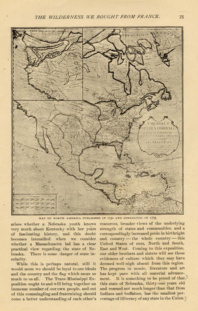
"When we took possession in December, 1803, the eastern boundary was the Mississippi from its source to the 31st parallel, but where that source was 110 man knew, and the boundary below :11 degrees was long in dispute, Americans claiming as far east-ward as the Perdido River. But Spain would acknowledge no claim east of the Mississippi and south III the 31st parallel save the
By the convention of 1818 with Great Britain, the utmost northern boundary of Louisiana Was to begin at 'the most north-western point of the Lake of the Woods, run due north, or south, as the case might be, to the 49th parallel of north latitude and westward along that parallel to the summit of the Stony Mountains." The region beyond (now Idaho, Washington and Oregon) was claimed by both parties. From this time for nearly thirty years the "straggle for possession" alternately waxed and waned until heroic Dr. Whitman made his immortal ride of 4,000 miles in midwinter and saved Oregon to the Union. This was in 1843. and by the treaty of 1846 the matter was peacefully settled. We are apt to congratulate ourselves on peaceful victories—and often they are cheaply won in every sense. If the old war-cry of "Fifty-four, forty or light" in 1846 had stood for anything we meant to stand by—in effect, fighting. and not temporizing should to-day he in control of a coast line connecting us with Alaska, and masters of a country wherein could arise no Klondike complications—of which country, and our right of entry thereon, we may be in-formed in no uncertain terms erelong.
A glance at the map will show the ex-tent of territory acquired by this purchase. Out of it have been carved nine whole states, namely: Louisiana, Arkansas, Missouri, Kansas, Nebraska, Iowa, Korth Dakota, South Dakota, Montana and a part of Minnesota, Wyoming and Colorado. The other part of Minnesota we derived from the North-west Territory and the remainder of Colorado and Wyoming from Mexican cessions.
Very interesting and very profitable is a study of the rise and progress of these states. this great domain we call the trans-Mississippi country. It will do no harm and possibly much good for us to review our history—too often neglected both in public and private education. Surely nothing becomes an Americans, young or old, more than an accurate, thorough, intelligent knowledge of his country—not in narrow sections, but with a view as broad as the land in which he lives. A doubt
While this is perhaps natural, still it would seem we should be loyal to our ideals and the country and the flag which mean so much to us all. The Trans-Mississippi Ex-position ought to and will bring together an immense number of our own people, and out of this commingling and fraternizing should come a better understanding of each other'sresources, broader views of the underlying strength of states and communities, and a correspondingly increased pride in birthright and country the whole country this United States of ours, North and South, East and West. Coming to this exposition, our older brothers and sisters will see those evidences of culture which they may have deemed well-nigh absent from this region. The progress in music, literature and art has kept pace with all material advancement. It is something to be proud of that this state of Nebraska, thirty-one years old and rescued not much longer than that from Indians and buffaloes, has the smallest percentage of illiteracy of any state in the Union.
 The state of Idaho, eight years old, raised on irrigated land apples which took first prize at the World's Fair.
But let us call the roll. Here are the states which will be present at the exposition from the trans-Mississippi country—the states representing the Louisiana purchase of ninety-five years ago.
Louisiana. Admitted as a state in 1812 ; 45.000 square miles of territory, or 28,-000,000 acres, and about 3,000.000 under cultivation. On these acres are grown sugar, *35,000,000; cotton, $21,00O.000; corn, oats and hay. $10.000,000, and other pro-ducts bring the total value of her output up to $75,000,000 annually.
Arkansas. Admitted in 1836; an area of 53,840 square miles, about the size of England; population in 1896 was 1,600,000. 5.000,000 acres under cultivation; annual live stock product, $21.000,000; farm products. $44,000,000 per annum; 19,000,000 acres of timber lands, and the largest deposits of marble in the United States.
Missouri. Admitted in 1821 ; population, 3,250,000; has an area of 69,415 square miles. Maine, Massachusetts, Connecticut, New Hampshire, Vermont, Rhode Island and Delaware could be put down side by side in its limits and still leave a margin of 900 square miles. 17, 000, 000 acres under cultivation.
Kansas. Admitted in 1861; 408 miles long by 208 miles wide; farm products, $140,000,000 annually; the corn crop of 1896 amounted to 221, 419, 414 bushels, valued at $35,633.013.
Nebraska. Admitted in 1867 ; an area of 76,885 square miles; 33, 000, 000 arable acres; the second sugar-beet-raising state in the Union, producing 15, 000, 000 pounds; has raised in one year 300.000, 000 bushels of corn on her portion of the "Great American Desert."
Iowa. Admitted in 1846 ; a grand agricultural state; her farmers raise products valued at $500,000,000 annually; corn, 285.000,000 bushels; oats, 200.000.000 bushels; 9,500,000 bushels of wheat; fruit crop. $3.000,000.
North Dakota. Admitted in 1889 ; population, 225,000 ; area, 70.795 square miles; world-famous wheat country — one farm contains 75.000 acres. The Dakotas produce annually upward of 60, 000, 000 bushels of wheat.
South Dakota. Admitted in 1889 ; area, 42,050 square miles ; population, 335,000; there are 50,000 farms in South Dakota valued at $170,000,000: raises 30, 000, 000 bushels of wheat annually.
Montana. Admitted in 1889 ; area, 146, - 080 square miles; population, 185,000; 30, 000, 000 acres of farm lands, 38, 000, 000 acres grazing land: in gold alone Alder Gulch produced $65.000,000. A rich state in minerals, agriculture and lumber.
Minnesota. Admitted in 1858 ; population, 1,610.000 ; area, 83,531 square miles; value of manufactured products, $792,000,-000; annual product of corn, 35.000, 000 bushels; wheat, 65,000,000 bushels; oats, 77.000, 000 bushels. It has the greatest flour-making city in the world, with a capacity of 38,000 barrels of flour per day. One of these mills has the greatest capacity of any flour mill in the world—it can produce 7,200 barrels of flour a day.
Wyoming. Admitted in 1890; an area of 97,890 square miles; 90.000 population; it is as large as all New England and Indiana combined ; its forest lands cover 10, 000, 000 acres; 1,500.000 cattle and 1,000,000 sheep are grazing all the year round, and the live-stock interest represents $100, 000.000 of capital.
Colorado. Admitted in 1876; area, 103,925 square miles—as large as all New England and Ohio combined; population 450,000. The bullion product of Colorado has reached beyond $300,000,000. but so accustomed are we to think of Colorado in connection with mines that it is forgotten she is a magnificent agricultural state—her farm products leading her mine products.
Thus briefly, hurriedly and imperfectly has the region of the old Louisiana purchase been outlined. There are great states lying outside the Louisiana purchase of which ex-tended mention should be made did space permit ; states whose early history of struggle and ultimate triumph is a most fascinating subject. The stories of Texas, of California. of Oregon, are those of history-making epochs in the progress of our country. These and the rest of the sisterhood of states from North and South and East will, at the Trans-Mississippi Exposition, receive a warm Western welcome.